Zugspitze
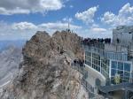
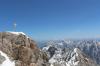
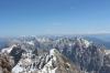
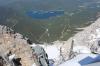
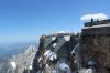
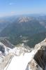
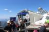
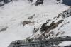
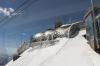
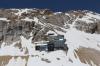
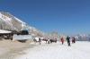
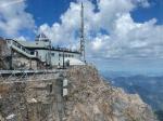
The Zugspitze, at 2,962 m (9,718 ft) above sea level, is the highest peak of the Wetterstein Mountains as well as the highest mountain in Germany. It lies south of the town of Garmisch-Partenkirchen, and the border between Germany and Austria runs over its western summit. South of the mountain is the Zugspitzplatt, a high karst plateau with numerous caves.
The twenty closest neighbours in the database:
Linderhof Palace (17 km),
Ettal Abbey (18 km),
Innsbruck (Austria) (36 km),
Landsberg (Germany) (70 km),
Kaltenberg (Germany) (79 km),
Wangen im Allgäu (Germany) (91 km),
Bregenz (Austria) (92 km),
Munich (Germany) (92 km),
Olympic Stadium Munich (93 km),
Lindau (Germany) (99 km),
Convent of Saint John in Val Müstair (101 km),
Allianz Arena (101 km),
Augsburg (Germany) (105 km),
Feldkirch (Austria) (107 km),
Langenargen (Germany) (110 km),
Principality of Liechtenstein (115 km),
St. Gallen (Switzerland) (119 km),
Chur (Switzerland) (127 km),
Meersburg (Germany) (132 km),
Lake-dwelling Museum of Unteruhldingen (135 km)
Take a birds-eye view of the current location:
Google Maps ,
OpenStreetMap ,
Bing Maps ,
Yahoo!Maps
37,568 pictures with 7,756.86 MB in the database. Page views: 62,756,921.
© 1996-2026 Stefan Plogmann
The pictures and texts of this website are licensed under a
Creative Commons Attribution-NonCommercial-ShareAlike 3.0 Unported License .
An approval for commercial usage can be requested by sending an
email to the author with a description of the intended usage.
This website may contain hyperlinks to web pages of third parties.
Stefan Plogmann accepts no liability or responsibility for the contents of such webpages and
does not take over such webpages as its own. The use of such pages shall be at the sole risk
of the user. Please also notice further legal information in the
terms and conditions of this page.
You are also welcome to visit my private homepage
www.plogmann.net .
To stay informed about updates and new images in this gallery you can use this
RSS-feed .